

West Coast Trail Map
The West Coast Trail Map is an essential navigation aid for hikers tackling one of the world’s most iconic coastal backpacking routes.
You can download the official West Coast Trail Map as a PDF or explore the interactive version in the West Coast Trail App, which includes tide charts, ladder locations, trail descriptions, campsite maps, and a full trail guide.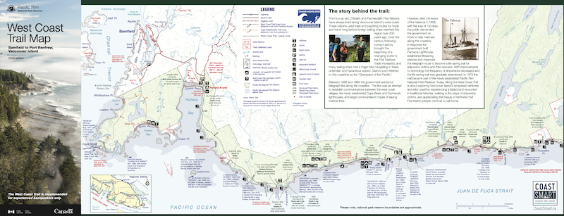
How to get the Map
Hikers beginning the West Coast Trail receive a free printed copy of the map during Parks Canada orientation. To plan your hike ahead of time, you can download the latest official map below.
What's in the Map
The map covers the entire 75 km length of the West Coast Trail, from Pachena Bay to Gordon River, and includes every major feature hikers rely on for navigation:
- KM Markers along the trail
- Official campsite locations including: Thrasher Cove, Camper Bay, Cullite Cove, Walbran Creek, Bonilla Point, Carmanah Creek, Cribs Creek, Nitinaht Narrows, Tsusiat Falls, Klanawa River, Tsocowis Creek, Darling River, Michigan Creek
- Points of interest like lighthouses, waterfalls, and viewpoints
- Cablecar locations
- Historic shipwreck sites
- Impassable headlands and tide-restricted beach sections
- Prohibited Camping Areas
The West Coast Trail changes over time, and Parks Canada updates the map every few years. The 2025 edition includes new reroutes and other key updates.
Enhanced Trail Map
The West Coast Trail App includes the same base map in an interactive, GPS-enabled format with even more detail than the paper version.
West Coast Trail is built for offline use, so you can navigate the trail without cell service and still see your live location on the map.


West Coast Trail is built for offline use, so you can navigate the trail without cell service and still see your live location on the map.
Digital enhancements include:
Ladders
Locations, rung count, and direction.
Tides
Restricted beach sections highlighted on the map.
Water Sources
Know which sources are safe to drink and the ones to avoid.
Danger Areas
Avoid impassable headlands and deadly surge channels.
Trail History
Detailed trail history and descriptions.
First Nations
Huu-ay-aht, Ditidaht, and Pacheedaht translations plus audio clips.
GPS on the Map
See your live location offline on the West Coast Trail.
Campsite Maps
Detailed campsite maps and ameneties.
Orientation Details
Where to go and what to expect at orientation.
Ferry Details
Ferry schedules and fees.
Trailhead Maps
Trailhead area maps. Places to stay and eat.
Owen Point Guide
Complete guide to navigating the sea caves.
...and much more inside the West Coast Trail App.
Map updates for 2025
The 2025 version of the Parks Canada Map includes the following changes from previous versions:
- Closure notice of Pachena and Camanah Lightstations
- Removal of beach-trail route via Camanah Lightstation stairs
- Warnings about Cullite Camp
- Warnings about Owen Point
Planning your West Coast Trail hike this year?
Download the FREE West Coast Trail App.
Download the FREE West Coast Trail App.
Last updated October 2025 with latest Parks Canada West Coast Trail sources.