West Coast Trail
Your essential hiking companion


Digital Map
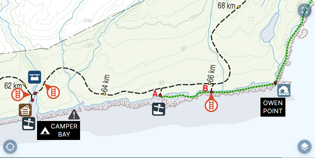
West Coast Trail uses a simplified version of the official Parks Canada Map and adds layers with interactive-icons so the most important details are at your fingertips.
Ladders
Locations, rung count, and direction.
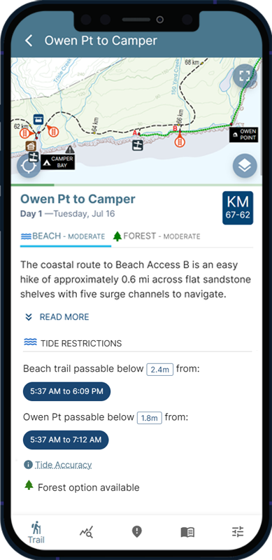
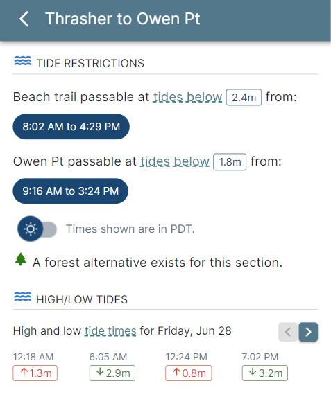
Tides
Restricted beach sections highlighted on the map.
Shipwrecks
Immerse yourself in history along the West Coast Trail.
Water Sources
Know which sources are safe to drink and the ones to avoid.
Points of Interest
Donkey Engines, Graders, Sea Caves and more.
Bridges & Cable Cars
Where and how to safely cross dangerous rivers.
Tides
No more fumbling with old-school paper tide charts and trying to adjust for Daylight Saving Time.
West Coast Trail uses Government of Canada tide data to show you the most accurate predictions on when restricted beach sections are passable.
Tides predictions are automatically adjusted for your travel date and shown with one-minute precision.
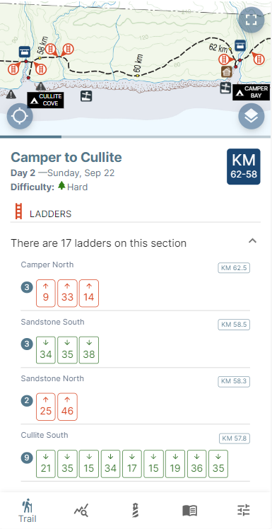

Ladders
Like climbing ladders?Did you know that the West Coast Trail has more than 100 ladders to climb and well over 2600 individual rungs to step up or down?
Wondering what your day will look like and how many Ladders you need to climb? If the beach will be easier than the inland route?
West Coast Trail has you covered.
West Coast Trail has you covered.
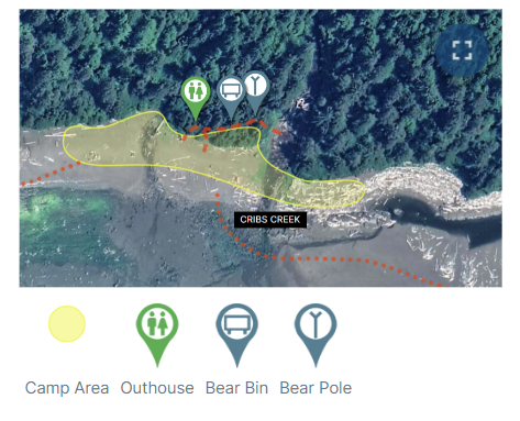
Camp Maps
Get the scoop on each campsite along the West Coast Trail with detailed satellite maps. Images show the best places to pitch your tent and the locations of amenities.
Includes the following camps:
Thrasher Cove, Camper Bay, Cullite Cove, Walbran Creek, Bonilla Point, Carmanah Creek, Cribs Creek, Nitinaht Narrows, Tsusiat Falls, Klanawa River, Tsocowis Creek, Darling River, and Michigan Creek.
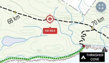
GPS Location
GPS location shows your exact point overlaid on the Parks Canada map together with your approximate KM-marker location along the West Coast Trail .
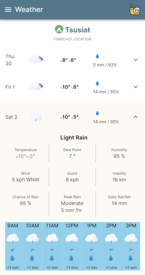
Trail Weather
Don't get caught in a storm. The West Coast Trail spans a whopping 75 kilometres (47 miles) of complex coastal terrain with many unique microclimates.
Trail Weather uses precision weather forecasts at precise GPS locations all along the West Coast Trail, including every campsite and other main locations.
West Coast Trail uses weather prediction models known to be the most accurate for the region, including those from NOAA and ECMWF.
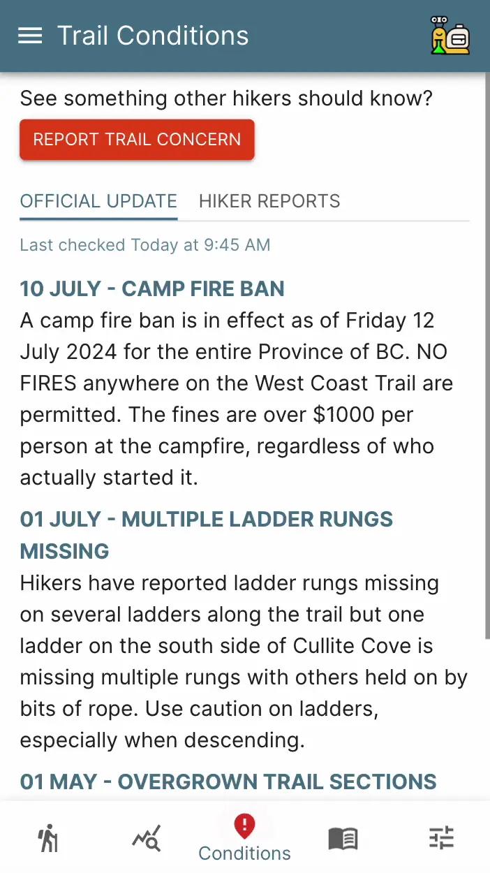
Trail Conditions
West Coast Trail partners with the team at Pachena Lightstation to bring you the most up-to-date trail conditions during the hiking season.
Pachena Lightstation is located right on the path of the West Coast Trail at KM10 and it is a favorite destination for hikers to visit and swap stories of challenges on the trail.
Choose Your Plan
Get all the essential features and planning tools for free or upgrade and be trail-ready with the full premium features.| Feature | Free | Plus $19.99* | Pro $29.99* |
| Digital Map | |||
| Tide Restrictions | |||
| Tide Daily High/Lows | |||
| Trip Builder | |||
| Trail Conditions | |||
| Shipwrecks | |||
| Water Sources | |||
| Ladders | |||
| Distances | |||
| Campsite Maps | |||
| Sunrise/Sunset | |||
| Daily Summary | |||
| Guidebook | |||
| Contacts | |||
| Emergency Info | |||
| Saved Trips | |||
| Offline Access | |||
| GPS Location | |||
| Trail Weather | |||
* Price shown is for a one-year subscription. | |||