West Coast Trail
Your essential hiking companion


Digital Map
West Coast Trail uses a simplified version of the official Parks Canada Map and adds interactive-layers so the most important details are at your fingertips.
Ladders
Locations, rung count, and direction.
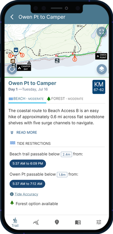
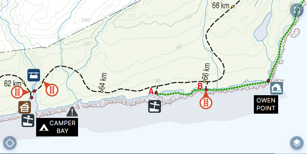
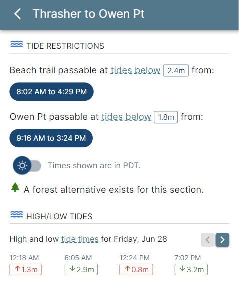
Tides
Restricted beach sections highlighted on the map.
Shipwrecks
Immerse yourself in history along the West Coast Trail.
Water Sources
Know which sources are safe to drink and the ones to avoid.
Points of Interest
Donkey Engines, Graders, Sea Caves and more.
Bridges & Cable Cars
Where and how to safely cross dangerous rivers.
Danger Areas
Avoid impassable headlands and deadly surge channels.
Tides
No more fumbling with old-school paper tide charts and adjusting for Daylight Saving Time.
West Coast Trail uses Government of Canada tide data to show precisely when restricted beach sections are safe to cross.
Tide times automatically adjust to your travel dates—with one-minute accuracy.
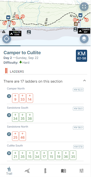

Ladders
The West Coast Trail has more than 100 ladders and over 2,600 rungs to climb or descend.
See exactly what’s ahead — how many ladders you’ll face in each section and where the toughest climbs are.
Whether you’re taking the beach or inland route, West Coast Trail shows every ladder and adjusts which ones you’ll climb or descend as you go.
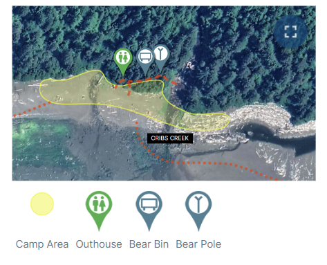
Camp Maps
Get the scoop on each campsite along the West Coast Trail with detailed campsite maps. Images show the best places to pitch your tent and the locations of amenities.
Includes the following camps:
On-Trail Map
The most detailed West Coast Trail map ever built.
Explore the entire trail in a full-screen, GPS-enabled map with hand-drawn coastline detail, reef hazards, and surge channels not shown on standard maps.
Zoom, pan, and explore the terrain with tide-restricted zones and important landmarks layered directly onto the map.
Works fully offline — with your exact position shown anywhere on the trail.
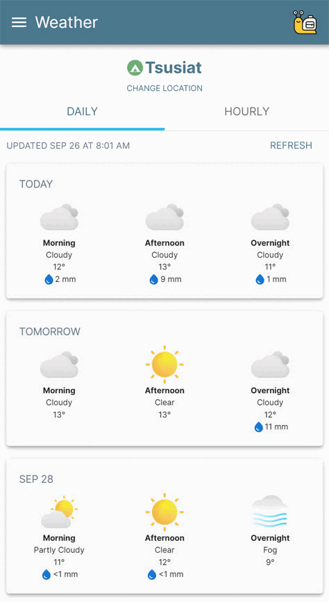
Trail Weather
Don't get caught in a storm. The West Coast Trail spans a whopping 75 kilometres (47 miles) of complex coastal terrain with many unique microclimates.
Trail Weather delivers pinpoint forecasts for every campsite and major location along the West Coast Trail — updated using the most accurate regional models from NOAA and ECMWF.
Stay informed, plan smart, and hike safely.
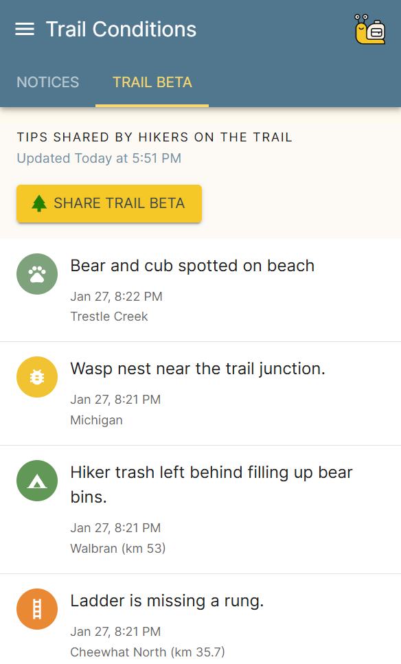
Trail Conditions
Know what to expect on the trail during your hike.
The West Coast Trail is monitored for hazardous conditions like river flooding, broken cable cars, fire bans, wasp nests, unbrushed sections and more.
West Coast Trail brings you the most up-to-date curated list of trail conditions during the hiking season.
Hikers can also pass on “Trail Beta” to warn fellow hikers of concerns found along the way.
The West Coast Trail is remote, complex terrain that sees over 100 search and rescue incidents each season.
Plan FREE — Hike PRO
West Coast Trail includes everything you need to plan your backpacking adventure for free, without ads.
Upgrade to PRO* when you’re ready to hit the trail and unlock the on-trail essentials.
FEATURE
FREE
$29.99
PRO*Digital Map
Tide Restrictions
Tide Daily High/Lows
Trip Builder
Trail Conditions
Shipwrecks
Water Sources
Ladders
Distances
Campsite Maps
Sunrise/Sunset
Daily Summary
Guidebook
Trailhead Maps
Orientation Details
Contacts
Emergency Info
Owen Point Tide Calendar
Saved Trips
Unlocked during trip dates
On-Trail Map
Offline Access
GPS Location
Trail Weather
*The PRO pass is a one-time purchase that unlocks all PRO features for the current trail season. Access is valid for the year shown on the pass.
By purchasing PRO, your support keeps planning free for everyone, ad-free.
By purchasing PRO, your support keeps planning free for everyone, ad-free.
Hiking the West Coast Trail requires a backcountry permit.